
Part I
The Alsea Stewardship Group hosted a field tour of the West Alsea Landscape Management Project in the Siuslaw National Forest on Saturday, May 12. Representatives of several agencies and the interested public attended.
Focuses were decommissioning roads, meadow restoration, riparian thinning of plantation stands, and in-stream projects to enhance fish habitat at various sites on Canal Creek and Drift Creek, tributaries to the Alsea River.
Drift Creek contributes about 15 percent of the watershed area, while Canal Creek contributes about 3 percent. Both basins are important fish production areas and support populations of Chinook and Coho salmon, steelhead and cutthroat trout, Pacific lamprey and several sculpin species. Canal Creek also supports a few chum salmon.
Diverse ecosystem
Shortly after the group gathered at the Waldport Ranger District Station, Randy Miller, wildlife biologist with the Siuslaw National Forest, Central Coast Ranger District gave an overview of project goals for area watershed restoration. He said, "The most important reference conditions are the natural ranges of variability for all habitat types at landscape and stand scales. The challenge of managing for a wide range of habitats is determining the desired distribution and abundance of these habitats, because increasing the amount of one habitat, such as old-growth forest, can also decrease the amount of other habitats, such as grass, forb, or shrub." Disturbance plays an important role in maintaining certain environments - such as low intensity fire for meadows, to remove encroaching vegetation. Miller said, "Ecosystem recovery should focus on the natural processes that affect habitats and the historic distribution and abundance of these habitats."
The range of historic abundance of the different forest several stages for the Oregon Coast Range is believed to be 12 to 29 percent early forest (less than 30 years old); 15 to 31 percent young forest (30 to 80 years old); 15 to 28 percent mature forest (80 to 200 years old); and 29 to 52 percent old-growth forest (greater than 200 years old). Existing forest several stage abundance in Alsea project area is 10 percent early, 45 percent young, 42 percent mature, and 3 percent old-growth.
Plantation stands contain as many as 200 to 300 trees per acre, and current projects aim to thin toward 80 trees per acre; the natural distribution of mature trees is between 10 and 40 per acre.
Habitats of concern are defined by project managers as having declined, or expected to decline, compared with historic abundance or distribution and in the Alsea project area. They are old-growth forest, important for large limbs or cavities, including hardwoods; grass and forb in meadows, and to some extent in the forest understory; shrub; and large dead wood such as cavities, snags, and downed woody debris. A range of species within a healthy ecosystem depend on a naturally varied environment.
Developing science
The science of watershed restoration is being developed. Miller cited a study, saying, "Although the processes that created the current late-successional and old-growth ecosystems are not completely understood, they include (1) tree growth and maturation, (2) death and decay of large trees, (3) low-to-moderate intensity disturbances (e.g., fire, wind, insects, and diseases) that create canopy openings or gaps in the various strata of vegetation, (4) establishment of trees beneath the maturing overstory trees either in gaps or under the canopy, and (5) closing of canopy gaps by lateral canopy growth or growth of understory trees." (NWFP ROD, p. B-2)
Meadows are a small component of watersheds upon which some species depend. Miller said meadows in the Alsea watershed have been encroached upon by woody plants, which were historically prevented from establishing in meadows by Native Americans who managed meadow lands with low intensity fires; and settlers achieved effective fire suppression by the 1910s. Aerial photos of the Alsea watershed from 1939 captured some upland meadows in Lower Drift Creek, Canal Creek, and along the major ridges surrounding the watershed. "In the 1940s era there were about 200 acres of meadow habitat on Forest Service lands," said Miller, "Now, there is about 50 to 60 acres of meadow habitat in the project area."
Shrub habitat, dominated by deciduous shrubs, was once common in the project area. "It was very abundant after wildland fires before around 1900, and it was abundant during the era of clear-cutting, about 1950 to 1990," said Miller, "The abundance of shrub/sapling habitat on Forest Service lands is less than occurred during the past; primarily due to the elimination of low intensity fire and the end of both clear-cut logging and broadcast burning of logging slash. The abundance of shrub habitat will continue to decline as the last clear-cuts on Forest Service lands develop closed canopies. Forested areas recently thinned near the project area exhibit some shrub recovery; however the distribution and abundance of shrub species probably remains below historic levels."
Miller said as much as "40 percent of Forest Service lands in the watershed no longer have historic/adequate amounts of large dead wood," and noted portions of Forest Service lands in the project area are composed of plantations with very few large snags. "Historically, these plantations were mature or old-growth forest that contained large snags and down wood," said Miller, "There are few, if any, opportunities to create large snags or large down wood in old plantations. However, within plantations, there is an opportunity to grow larger trees that can become large dead wood in the future."
In summary, Miller said, "The primary emphasis of the desired post-treatment condition is to assure enough trees remain to supply dispersal habitat for the spotted owl, to meet the longer term desired amount of large live trees and large dead wood, and to hasten development of a few very large trees. The secondary emphasis is opportunities to maintain or create grass/forb, shrub, and dead wood habitat."
Part II
The group of agency representatives and interested public began the field tour on Canal Creek, where Jack Sleeper, fish biologist with the Siuslaw National Forest, Central Coast Ranger District identified a healthy riparian reference condition adjacent to Canal Creek Campground. The site suffered little disturbance after the 1850s fire and subsequent fires. Large woody debris down from the surrounding mature forest sponsors fish habitat, and live trees provide appropriate cover to preserve cool water temperature upon which salmonids and other fry depend. Sleeper explained, in areas where an inadequate supply of downed wood enters the stream system, a valuable nutrient source for the stream is lost. Wood collects wood in jams on the stream and as wood is less prevalent the natural process of sediment distribution, and sorting amongst and around woody debris, is diminished. Gravel beds are important to several fish species during spawning.
The tour continued a little way down stream where Sleeper identified cabled fish structure projects which he said continue to create and maintain high quality fish habitat in most areas treated. "They have made the stream more productive by retaining nutrients (leaves, needles, wood pieces, salmon carcasses) and sediment (gravel and cobble) needed for fish spawning areas and aquatic insect habitat," said Sleeper, "This roughness in the river also creates slow water areas during floods that are needed for juvenile fish to survive the high water."Today, rather than cabled structures, fish biologists recommend large woody debris be introduced to streams. "Limitations of this early restoration work are the relatively small pieces of wood used which limits the amount of high quality fish habitat created and the limited extent of the treatment to only a few short stream segments," said Sleeper. "The main reason for adding larger pieces of wood is to create more extensive, higher quality fish habitat. Our monitoring and the scientific literature have found that wood pieces longer than the stream is wide are unlikely to move, and if they do, they don't move far downstream, thus eliminating the need for cabling."
The new Bear Creek culvert (which runs the stream beneath the road) was the next stop. Sleeper said the culvert has been a partial fish passage barrier for adult salmon and a complete barrier for juvenile salmon for 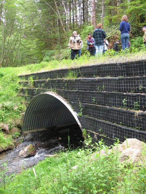 several years. "In addition, the old culvert was much smaller than the stream was wide so it tended to collect sediment upstream and scour sediment downstream of the culvert resulting in poor fish passage through the culvert." The Siuslaw National Forest replaced the old Bear Creek culvert with an open bottom arch culvert as wide as the stream. "Streambed sediments of various sizes (gravels, cobbles and small boulders) were placed in the stream to create a natural streambed through the culvert to facilitate fish passage," said Sleeper, "Monitoring has found that the culvert upgrade is providing fish passage for adult and juvenile salmon after winter high flows."
Decommissioning roads was the subject of several stops during the day. A 13-year-old road decommission was fairly well overgrown, though invasive species may inhibit the establishment of some native plants. Of stewardship flexible funds received by the area agencies, none are dedicated to decommissioning roads, which may cost upwards of $40 thousand per mile for a full treatment - including re-contouring the hillside and bucket-ripping to fluff the compacted surface. Restoring former roads to a natural state is expensive, but removes a barrier inhibiting the health of riparian zones, lowers nearby stream temperatures, and contributes important woody debris to nearby streams in the long run.
A meadow located nearby on Canal Creek, called Robnett Meadow, was the next stop where the group lunched before exploring. The meadow was purchased by the Siuslaw National Forest in recent years and was an old homestead. Toured were a healthy jam of woody debris, where a mature tree fell over the water downstream; and the riparian area of the meadow, which was recently planted with cedar, hemlock and spruce. "The upland areas remain in meadow," said Sleeper, "The plantings are intended to widen the narrow forested riparian area near Canal Creek and diversify tree species present."
After lunch the tour continued to the Oxbow Meadow on Drift Creek, which was also homestead land and acquired in recent years from a timber company by the Siuslaw National Forest. Jan Robbins, hydrologist with the Siuslaw National Forest, Central Coast Ranger District explained the meadow used to be extensive agricultural fields diked against the tidal influx to improve grazing lands. A large portion of the land was planted with conifers by the timber company in the interim.
Many restoration activities are intended to restore natural processes that create and maintain plant, fish and wildlife habitats. "Roads, dikes, wetland drainage, stream channelization, and riparian tree removal have resulted in many streams and tidal channels being disconnected from their floodplains," said Sleeper, "Streams and floodplains feed each other. Floodplains feed the aquatic ecosystem when flooding inputs plants, animals and nutrients from the floodplain to the stream, tidal channel, or estuary. The same thing happens when the stream deposits water, plants, animals and nutrients on the floodplain."
The Siuslaw National Forest in cooperation with the MidCoast Watershed Council and others have recently removed dikes, drainage tiles and culverts that altered natural hydrologic processes and blocked fish passage. Sleeper said, "Hundreds of Coho salmon juveniles are now using the two plus miles of tidal channels that had been blocked for several decades before they were restored." The Confederated Tribes of Siletz monitoring via camera fish in the slough draining into Drift Creek at Oxbow Meadow, in a funding partnership with MidCoast Watershed Council, Oregon Watershed Enhancement Board and National Oceanic & Atmospheric Administration (NOAA) Fisheries.
Much of the meadowlands are currently covered with non-native vegetation. Robbins said forestland managers recognize the impossibility of removing all introduced plants, distinguishing between invasive species and those which do not proceed to usurp land. She said introduced plants are being removed while native riparian plants are being planted in some areas, to encourage the viability of native populations. The homestead properties toured contained ornamental plants such as rhododendron, apple and cherry trees. Wayne Hoffman, in attendance representing the MidCoast Watershed Council, called these plants "cultural artifacts."
The Rocky Mountain Elk Foundation supports the Oxbow Meadow mow and burn, which is expected to be an annual effort and to encourage production of healthy native elk forage.
Volunteers for a variety of restoration projects are encouraged to call Paul Thomas, leader of the West Alsea Landscape Management Project, Siuslaw National Forest, Central Coast Ranger District at 563-8426.
West Alsea Landscape Management Project
Planning monies for the West Alsea Landscape Management Project comes from congressionally appropriated funds. Implementation and monitoring of the various projects proposed encompasses a variety of federal and state sources.
"Comments from the Alsea Stewardship Group and private citizens are very useful in helping us develop and think through the proposed projects in the West Alsea Landscape Management Project," said Sleeper, "The Alsea Stewardship Group will help implement some of the proposed projects after the Environmental Assessment is complete."
The project area includes the Alsea 4th field which is the entire Alsea Basin; the smaller ocean tributary basins south of Alsea Bay south to and including the Horse Creek basin just south of Sea Lion Caves; the small ocean tributaries north of Alsea Bay to and including the Beaver Creek basin; and the tributary basins of the Yaquina River that flow out of Siuslaw National Forest land, specifically the Upper Big Elk, south-side tributaries of the Big Elk, Mill Creek, and Wright Creek. Communities in the project area include Alsea, Tidewater, Waldport, Yachts, Seal Rock and Harlan.
The process of developing a stewardship contract is collaborative and community-driven by those who have a common vision or resource interest. The Alsea Stewardship Group is a collaboration of local organizations, private landowners, local residents, timber industry representatives, environmental groups, the United States Forest Service, Bureau of Land Management and other interested parties. Alsea Stewardship Group is working with the Siuslaw National Forest, to develop stewardship contracts, a collaborative approach seeking to restore watershed ecosystems and provide jobs for local communities.
Stewardship contracting is intended to achieve key land-management goals that improve, maintain, or restore forest or rangeland health; restore or maintain water quality; improve fish and wildlife habitat; reestablish native plant species; reduce hazardous fuels in regards to fire risk to communities and ecosystems - and work with local communities to achieve these goals.
This field tour was the first of two West Alsea Landscape Management Project field tours. The second field tour is scheduled June 2 and will focus on upland reference conditions, plantation treatments, dead wood and creation of small openings within plantations. The public is welcome to attend, given a restricted number of participants. For more details contact Linda Johnston with the Alsea Watershed Council, 528-3221 or [email protected].